Renovate Me catches up with Richard Mckie, Director of Operations at Qopter360 for his thoughts on the use of drones in renovation projects.
What uses are there for drones in renovation projects?
Photographic evidence of your site can help with building regulation approvals and applications. Visual inspection surveys using UAS technology can be used in preliminary surveys to ascertain the extent of the damage. This can be very useful as part of a pre-purchase and will make you aware of any obvious problems that may need fixing from above. The use of drones in renovation projects can be favourable over traditional methods of visual inspection because the technology is quick to deploy. The drone is able to access hard to reach areas of the roof which may be out of reach of traditional Mobile Elevating Work Platforms (MEWP) systems. Some sites have limited access and a commercial drone pilot does not have the large footprint that these systems use.
Unmanned Aerial Systems (UAS) can be used during all phases of a renovation project. They can assist in identifying structural issues which may be a risk during the project and will show areas of significant damage on the roof or identify areas where lead flashing is needed. Having an aerial shot of your site can help you plan ahead for access of machinery or materials. These shots are a great way of keeping stakeholders updated about developments on your project and can help make great looking project progress reports. They can also be shared with contractors working on your project including architects and building surveyors to ensure alignment and clarity throughout. Photos of your site are great record or evidence of milestones during the works.
The use of UAS and 3D modelling software allows construction of 3D models of sites at various stages throughout the project lifecycle which can be a powerful tool when considering stakeholder wants, needs and expectations.
How would a drone be of use to a large-scale property developer?
The images from commercial drones can be utilised for both analysis and presentation.
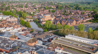
Before a project has commenced, they can be used to map out an area planned for development as part of a project plan or charter. The imagery can be shared with consultants working on the project and can be a valuable resource. With large developments, we are able to create video tours of the sites and provide a 3D map of the site, including the terrain maps of the land.
Property developers use aerial photos as promotional content for the purchase of properties on their site. They are a great way of showing not only the buildings footprint but also the land included in the purchase and can even help simulate what a view from a property may look like from yet to be built properties.
Aerial vantages are also great for asset management and can help project managers make strategic decisions about the location of plant machinery on sites and the movement and storage of materials. We have even seen them being used in site inductions to clearly point out areas of risk, driving routes around sites and areas to avoid. Again, project progress reports will document the progress of any developments and keep stakeholders informed ensuring businesses are establishing good relationships with the key groups of people who have an interest in any development.
I have a drone and I’ve seen a property I’d like to purchase; can I send my drone up to check the roof?
Unless you have Permission for Commercial Operations (PfCO) from the Civil Aviation Authority (CAA) then the answer is “No”.
The CAA term ‘commercial operations’ as “’…any flight by a small unmanned aircraft…in return for remuneration or other valuable consideration”.
Only commercial operators can operate drones within 150m of congested areas and there are many other considerations including but not limited to the proximity to other buildings and properties that are not under control of the pilot in command. Without the correct permissions, experience and the right insurance, you are breaking the law. Due diligence should also be carried out by people contracting drone pilots. One place to start is looking for a unique UAS number issued from the CAA.
A professional commercial drone operator will have all the necessary permissions to fly and will have received recommendation from a UK National Qualified Entity for remote pilot competency conforming with UK law. They will carry out risk assessments on and off site to ensure they are operating within safe limits and provide you with peace of mind when you are running your business.
It is unlikely that a non-commercial pilot will have the correct training or understand airspace infringements, NOTAMS and geofencing which are just some of the considerations which can affect your project.
Can you give a case study of the use of drones in renovation projects?
Yes, Qopter360 Ltd worked in collaboration with Approved Inspectors Ltd on the visual inspection of a property in a congested area. The property was suffering from water ingress due to a deteriorating roof and was located in an area with limited access. Typically building surveyors may consider Mobile Elevated Working Platforms (MEWPs) to gain access and ascertain the extent of the damage however these come with a limited reach, have their own associated costs and take a great deal of planning and organisation to get them in the right place that they are needed. Qopter360 worked with Approved Inspectors on this occasion to deliver a better solution and provide high-resolution imagery of the roof of the building. This allowed their qualified and experienced surveyors to make informed decisions about the state of the roof and further actions to be taken. As part of this project, Qopter360 took care of a large part of the project planning, which is a standard part of our organisational procedure. Communicating the project with the local authority, landowners and local services.
What is orthophoto?
An orthophoto is basically an image or images that have been stitched together and orthorectified. This means that terrain and perspective have been removed so that objects are shown in their true horizontal position. Features are shown in their actual location and true distances can be measured between points. The 2D digitised data can be used to create maps of a site or area. These images can also be overlaid on to maps to get an idea of changes in terrain or forested areas.
Is using a drone expensive?
The short answer is that drones can be as expensive as you want them to be.
Using commercial grade drones to safe and professional standards comes with a cost. There are many things a commercial drone pilot needs to consider. Insurance’s, training costs, ongoing personal and professional development and supplementary equipment comes at a cost. Commercial operations often require the use of your drones for extended periods of time and this means you need redundancies in place in terms of power and platforms. Time is a critical resource which people often forget to consider. Qopter360 invest time into planning our flights, additional safety measures are more often than not required to operate in specific areas
As a hobbyist you can obviously choose a drone according to your appetite for cost however it is still necessary to obtain public liability insurance and possibly hull or damage insurance for your equipment. Legislative requirements will soon require all drone pilots to register their drones so there will be fees here that people should consider.
There are many types of drones and an even wider array of payloads. Each offers a solution to a particular problem or need so it is important to consider fully what you will use a drone for before you invest in any platform. Acquiring the right level of knowledge is as important as having the right drone. Purchasing a drone does not necessarily mean you have the correct understanding of how to fly it, access and manipulate meta data within the files and produce the appropriate output to meet your clients wants, needs and expectations.
As a commercial drone operator, you need remember you are a service provider and it is this that Qopter360 focus on developing. We invest not only in our equipment but also organisational framework, processes and culture to ensure we provide our clients only the best service.
Do I need a permit to fly a drone?
To fly a drone for any commercial purpose, i.e. If you expect to receive any type of remuneration or benefit from the use of your drone, the answer is “Yes you require CAA permission”. The CAA however do not issue a permit as such, it is a permission. You often need additional permits or permissions to fly your drone in certain areas.
As a hobbyist, the onus is on you the pilot to fully understand the legal requirements you must adhere to. This is a legal responsibility and is statute law formed by acts of parliament. Civil Aviation Publication (CAP) 658 “A guide to safe flying” is a good place to start for hobbyists or if you are considering buying a drone.
Depending on the size of your drone you may require a different class of permissions. Countries also have their own local legislation and requirements for drone use, and it is important to understand these before considering travelling with your drone.
How close are you allowed to fly a drone near buildings?
As I mentioned already, only commercial operators can operate drones within 150m of congested areas. A recreational user must remain 50m away from buildings that are not under their control at all times. As commercial operators we adhere to slightly different rules during take-off (30m) and during the flight (50m). For buildings which are under our control we do not have to adhere to the same restrictions.
Beyond this legal framework the pilot in command needs to consider a number of other variables including but not limited to weather conditions, their own experience and any other variable which may affect the dynamic risk assessment which is carried out on site. Often, we consider the number of support crew, complexity of the flight and use risk assessments and decision trees to ensure we are operating safely at all times.
Could drones be used in the planning application stage?
Planning authorities and planners take full advantage of the data they have available to them. Only information submitted with an initial application is generally considered and there might be additional costs to resubmit an application. Data collection is therefore considered an integral part of the process. We are seeing more and more now that businesses are capitalising on the data that they collect. We only have to consider the English adage “A picture is worth a thousand words” and we can see the benefit of capturing high resolution imagery of a site.
LIDAR or light detection and ranging data is often used in engineering disciplines and for the construction of roads and buildings. Drone technology can also create similar Digital Elevation Models (DEM) and 3D models of a surface which can be used in the creation of flood risk assessments and surface water run-off models which can form part of planning applications for buildings, quarries and landfill sites. Environmental Impact Assessments could also benefit from photographic evidence of a feature or habitat. For applications to be successful the regulators or people determining your application need to be satisfied that the information in the application is sufficient for them to determine the Application. Having as much insight as possible allows them to make better-informed decisions about your application.
If you are a consultancy then supplying your people with as much information as possible allows them to make informed decisions giving you competitive advantage, putting your business in a position to succeed.
Can drones help create a 3D model of a building?
Drones are a great way of creating 3D models of buildings and scenes. To do this we use ‘photogrammetry’ which is essentially measuring using photographs. When you take two or more photos of the same object from a different point of view you can estimate the position of an object. We record the location that a photograph was taken from two points and we then find corresponding points or pixels between two photographs. Using this information, we are able to determine the distance to an object in a scene using trigonometry. We need to make sure that every part of the building is seen in at least two photos. We do this by flying grid patterns over a building or area and taking photos at intervals. For full 3d constructions, we will fly around an object or building taking pictures from different angles.
3D models are also used in other fields of study and can help us better understand how terrains or landslides are moving.
Can the data collected by a drone be used in SketchUp and AutoCAD?
The answer is “Yes”. Point clouds and textured 3D models from aerial images can be used in a range of software options. OBJ is a 3D model format. DWG or Drawing files are most commonly used in AutoCAD. There are a number of conversion options available which will allow you to get your OBJ files into AutoCAD by converting them into DWG files. There are plenty of opensource software alternatives out there which can also render and edit 3D models. There are other photo match options within SketchUp which can be used to quickly build representative models from aerial images which were captured using drones. These are not great for creating highly detailed models, but you can apply textures quite quickly.
Many thanks to Qopter360 for assisting with this article.